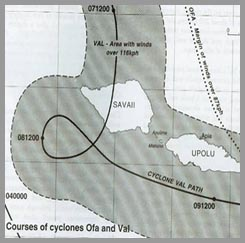
 Dec.2011 SIMULATION, Samoa Cyclone Mapping monitor
 Click to see Situational Reports content
Dec.2011 SIMULATION, Samoa Cyclone Mapping monitor
Click to see Situational Reports content
Click to see Situational Reports content
Dec.2011 SIMULATION, Samoa Cyclone Mapping monitor
Click to see Situational Reports content
Map Overlays of Samoa Island (Kml files)
Thanks to David Leng for the Overlays (Gov. of Samoa and JRC)
describing various aspects of Samoa. Some Kml files are huge. Before selecting, zoom to max extent and wait for content to show. This information is to be used for Simulation purpose only. We do not have the authorization to integrate this information into OSM.
Situational Reports Overlays (GEORSS Feeds)
Work derived from Bing Imagery and from Nextview, UNOSAT during the Simulation period, can be reused.
Please use the following Imageries and specify as source of imagery when editing.